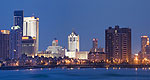
For quintessential East Coast casino hot-spot it's hard to beat Atlantic City, the boardwalk edged, beach padded gambling destination of choice for those after slots and coastal sunshine.
New Jersey Route 29 is located on the east side of the Delaware River. It runs parallel to the Delaware and Raritan Feeder Canalfor most of the length of the byway. It offers spectacular views of the Delaware River and travels through the historic riverside towns of Titusville, Lambertville, Stockton, and Raven Rock ending at the southern edge of Frenchtown. Historically significant in the American Revolution, Washington Crossing State Park is located near the spot where George Washington crossed the Delaware River and made his march into Trenton to capture the Hessian garrison and turn the tide of the American Revolution.
We offer a compact version of Go-New-Jersey for mobile users, allowing you to access just the information you need on the road. Of course, you can still use the full version of Go-New-Jersey on your mobile device just as you can on your desktop.