Home to the ivy-leauge school of the same name, Princeton, New Jersey, has the expected population of youthful collegiates but also offers access to a range of outdoor activities, from hiking and golfing to kayaking and bird-watching.
From Interstate 10, take highway 385 south to Fort Stockton and then on to Marathon. From Marathon, go 40 miles south on Highway 385 to the north entrance of Big Bend National Park. Drive straight 26 miles to Park Headquarters at Panther Junction. Turn right and drive for three miles. Turn left at the Basin sign and go seven miles to the campground.
Basic Info
Total Sites:
62
This campground is a hub for hikers. Some of the park's most spectacular and popular trails are nearby, including the Lost Mine Trail, the Window Trail, the South Rim Trail and the Pinnacles Trail, with access to the park's highest point, Emory Peak (elevation 7,825 ft.). Campers can find the trailheads for most of these trails in the main Chisos Basin area a mile or so further down the basin road from the campground.
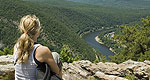
Access to the river is a few miles away, where visitors can canoe, kayak and fish.
We offer a compact version of Go-New-Jersey for mobile users, allowing you to access just the information you need on the road. Of course, you can still use the full version of Go-New-Jersey on your mobile device just as you can on your desktop.


")

