


Transportation information for Camden is provided below. Travel information includes driving directions, maps, airport information and more.
Transportation Services
Starr Transit Co Inc
- Cherry Hill
- Transportation Services
- 856-665-2209
VIP cab service
- pennsauken
- Transportation Services
- 856-308-1895
T & L Transportation
- Gibbsboro
- Transportation Services
- 856-783-6609
Friendly Express Limousine
- Philadelphia
- Transportation Services
- 215-776-8969
Preferred Limousine & Car Service
- Manahawkin
- Transportation Services
- 732-353-3024
Transit Services Inc
- Westville
- Transportation Services
- 856-384-9989
AAA National Svc
- Camden
- Transportation Services
- 856-479-7890
Vision Express/Wrag-Time Trans
- Haddon Heights
- Transportation Services
- 856-573-9600
Cherry Hill Station Inc
- Cherry Hill
- Transportation Services
- 856-428-2226
Class I Bus Co Inc
- Philadelphia
- Transportation Services
- 215-934-5885
Self Bus Svc Inc
- Cherry Hill
- Transportation Services
- 856-665-1248
Pennsauken Cab Services
- Merchantville
- Transportation Services
- 856-330-7178
Avandale Taxi
- Sicklerville
- Transportation Services
- 856-562-6110
Central Jersey Transportation
- Toms River
- Transportation Services
- 732-703-6595
American Eagle Taxi & Transport
- Glassboro
- Transportation Services
- 856-202-7036
Marinero Taxi
- sicklerville
- Transportation Services
- 856-879-4109
Airports
The nearest major airport is the Philadelphia International Airport which is located approximately 10 miles from Camden and is one of the larger airports in the nation. Thirty airlines provide 700 daily non-stop flights to more than 120 destinations including approximately 30 international destinations. The airport serves more than 30 million passengers per year.
Map + Directions
Basic Directions
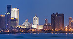
Camden is located on the western border of New Jersey in the southwestern part of the state, and is just across the river from Philadelphia. It is served by NJ Transit, and the NJ Turnpike runs just east of Camden. Route 130 runs north/south from Trenton to Camden.

